There’s something quietly magical about 3928 West Canal Road. Perfectly positioned within Severn Township, it rests right at that natural entry point where the smooth landscape of Southern Ontario gives way to the ancient rock of the Canadian Shield — a visible shift you feel as soon as you cross into Sparrow Lake.
This gorgeous, expansive property sits lovingly on the banks of the Severn River, where time slows and water speaks. Easily accessible from Highway 11, you’ll find yourself moments from the city yet miles away from its pace – and from your dock, it’s only a short, scenic river ride into beautiful Sparrow Lake.
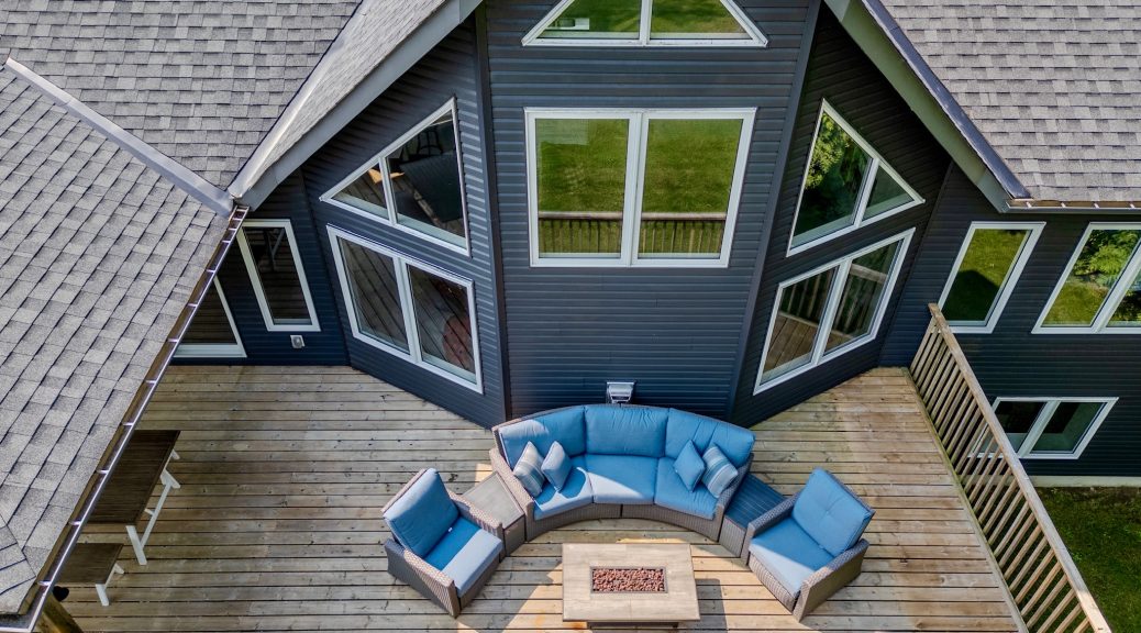
The home itself – almost 3,000 square feet – unfolds gracefully over two levels. Large windows invite the light and the view inside, while three fireplaces add that unmistakable Muskoka warmth. There’s space for everyone here: three bedrooms, two family rooms, an open-concept kitchen that gathers people together, and a walkout leading straight to the shore. The level yard invites laughter, play, and barefoot evenings by the fire pit under the stars.
Down by the water’s edge, a gentle shoreline opens to a private dock and deck – and beneath the trees, a shaded nook for quiet reflection or morning coffee.
From here, adventure radiates in every direction: hiking trails that wind through forest air, calm paddling routes, and winter paths perfect for snowshoeing or snowmobiling. And of course, there’s that irresistible truth – from the Trent–Severn Waterway, you can literally boat around the world. It always makes me smile (and maybe dream a little) to imagine setting out from your calm cottage dock and one day gliding into the St. Lawrence Seaway.
For full details, see MLS #S12330700 – and imagine yourself here, where the river begins to whisper “welcome home.”
Subject: Keep Muskoka Sparkling – Renew Your MLA Membership
Open Letter to Our Clients
When you close your eyes, can you hear it? The gentle lap of water against sun-warmed rock, the call of a loon across the bay, the scent of pine carried on a soft breeze. Muskoka has a way of weaving itself into our hearts, becoming not just a place, but a part of who we are.
That is why your membership in the Muskoka Lakes Association matters so deeply. Since 1894, the MLA has been the voice and the guardian of this shimmering paradise, protecting our water quality, standing watch over our precious shorelines, and celebrating the timeless joy of cottage life.
Your 2025 membership was gifted to you, and I truly hope you’ve felt the connection it brings, because updates keep you informed, events gather us together, and our community cares as much about Muskoka as you do.
Now, as the season turns, I warmly invite you to renew your membership for $150 and continue standing with us in protecting all that makes Muskoka magical, the sparkling lakes, the whispering pines, the rugged granite, and the laughter of families at the water’s edge.
Renewing is more than a transaction, it’s a declaration: I belong here. I care about this place. I will help protect it for generations to come.
Your renewal keeps Muskoka’s waters clean, our traditions alive, and our voices strong.
Please take a moment today to renew your membership at www.mla.on.ca.
Thank you, from my heart, for being part of this story. Together, we keep Muskoka shining.
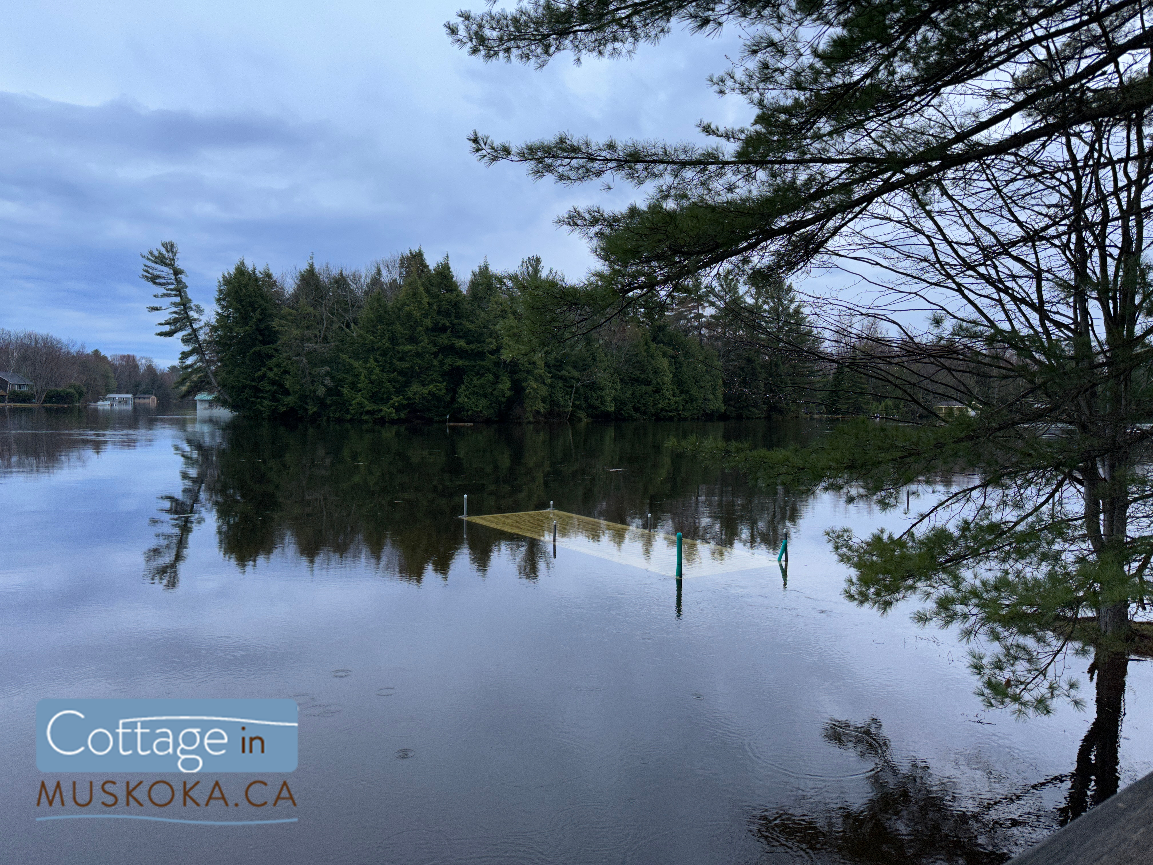
There are a few things that contribute to flooding in Muskoka, which we mostly experience along the Muskoka River Watershed – one of four watersheds in Muskoka. This watershed includes the Muskoka River, Moon River, Lake Muskoka, Lake Rosseau, and Lake Joseph, among others.
Duke’s (Duke boats) in Port Carling, Muskoka, ON. April 21, 2023.
Building location
The first major factor is where we’ve built cottages and homes. Many of the builds in the areas that experience the most flooding in Muskoka (Muskoka River, Lake Muskoka, and Moon River) are built on floodplains. In fact, builders on Lake Muskoka have started to build with that in mind… and not just by raising docks and boathouses! I saw a post made by Corbin Patten Designs on Instagram recently where they had included a raised section in a boathouse to keep a beer fridge safe during future floods.
If you don’t know what a floodplain is, it’s an area adjacent to a river or other watercourse that is susceptible to flooding. Floodplains are typically low-lying and flat, making them ideal for the slow accumulation of water during periods of high precipitation or snow melt. While these areas provide important ecological functions like natural flood control, water purification, and habitat for fish and wildlife, unwittingly building on a floodplain can be disastrous. Ensure that you are checking floodplain maps before you build or buy!
Flooding in Muskoka can be caused by a variety of environmental factors, including the amount of snow pack here and in Algonquin, the speed of thaw, and the level of precipitation. The Muskoka River watershed has its headwaters in Algonquin, and the amount of snowpack there significantly affects flooding here. When there is an above average amount of snow pack in Algonquin, it can lead to a larger volume of water entering Muskoka’s waterways during the spring thaw. The speed of thaw is also crucial in determining the severity of flooding in Muskoka. If temperatures rise too quickly, the snow and ice can melt too rapidly, overwhelming the local waterways and causing flooding. Finally, the amount of precipitation during the spring months can also contribute to flooding, as heavy rains can cause rivers and lakes to overflow their banks. All of these factors must be taken into account when predicting and preparing for potential flooding events in Muskoka.
Limitations to MNRF control
Okay, and here’s a reason that not many people seem to know… the dams along the Muskoka River Watershed are NOT flood control structures! The MNRF can draw down water to prepare for potential flooding, but beyond a certain point there’s nothing they can do to stop it. Here’s an excerpt from the 2019 Ontario Flood Report:
“It must be emphasised that dams in central Ontario, including those in the Muskoka River watershed, are not flood control structures. Flood control structures require a large lake or reservoir and associated drawdown capacity to store or hold back flood waters. Analyses have confirmed that lakes in the Muskoka River watershed that are regulated by dams have a limited capacity to drawdown water to affect flooding, and during periods of large volume rapid runoff, the available drawdown capacity is insufficient to reduce peak flood water levels. In this sense, the greater the magnitude of the flood event, the less ability the MNRF has on affecting or mitigating flooding through operation of its dams. Once the dams are fully open, the MNRF does not have the ability to increase the rate of flow, as it is then based on the amount of water in the system and the natural rate of flow and elevation as it moves through the wide-open dam sluice ways.“
There’s also a limit to how much they can draw down the water levels which has nothing to do with the dams, and more to do with the creatures we share Muskoka’s waterways with. Drawing down water levels can have a significant impact on lake trout spawning. Lake trout are a cold-water fish species that require specific water temperature and oxygen levels to successfully spawn.
In many cases, lake trout will spawn in shallower water nearer to the shoreline than their usual habitat. However, if water levels are drawn down too quickly or too far, the shallow spawning beds may become exposed to the air, causing the eggs to dry out and die. Additionally, sudden changes in water levels can cause currents and turbulence that can dislodge the eggs from the spawning beds, reducing the chances of successful hatching and survival. As such, water managers must carefully consider the impact of drawing down water levels on lake trout spawning and take steps to mitigate any negative effects.
A flooded dock next to Patterson-Kaye Resort on Lake Muskoka in Bracebridge, Muskoka, ON. April 21, 2023.
So, what can we do about flooding in Muskoka?
Well, here’s what the Ministry of Natural Resources and Forestry can do:
Muskoka River Water Management Plan (MRWMP)
The MNRF is responsible for managing the water resources in Muskoka and has developed a comprehensive water management plan to mitigate the impact of flooding events and protect the local ecosystem.
The plan includes a range of measures, such as monitoring water levels and flows, managing dams and water control structures, and providing timely warnings to communities in the event of flooding. You can check out the full Water Management Plan here.
The MNRF also works with other government agencies, local municipalities, and community groups to develop and implement best practices for managing water resources in the region. These practices include promoting the use of permeable surfaces to reduce runoff, and restoring wetlands to provide natural flood control. Overall, the MNRF’s water management plan aims to balance the needs of the local ecosystem with the social and economic benefits of water use in the region.
And as for us?
Be prepared
Expect flooding if you cottage or live in certain areas – in particular the Muskoka River, Lake Muskoka, and Moon River, or on any floodplain. Prepare your property, dock, and boathouse when you close your cottage in the winter. Sign up for our newsletter – you’ll be reminded when the time comes, and you’ll be shown exactly how to close your cottage and prepare for potential spring flooding. I’ll be sure to add an additional post about bracing for a flood before the spring 2024 flood season in Muskoka.
Use a local real estate agent
Not only do we know what areas flood (and see it firsthand), we’ll make sure to review floodplain maps as part of our due diligence – something that a Toronto real estate agent wouldn’t necessarily think to do. I would not be the first person you would ask about problematic condo buildings in the city or the areas of Toronto with the best walkability, and they should not be your trusted source for information about Muskoka.
Continue monitoring the situation when the water level begins to decline
The first sign of receding water levels is not the time to stop monitoring the situation.
First of all, high levels of precipitation, additional snowpack melting and adding water to the watershed, and dams flows being reduced to relieve flooding further down the watershed can all cause the levels to start rising again.
But here’s the bit everyone seems to forget – let’s say the water level was high enough that your boat is floating around in your boathouse. I’m sure you’ve secured it carefully, and removed anything that could damage it. But what happens when the water level drops? You need to make sure the boat makes it back into the slip. Not only can you damage your boat and the boathouse, but how would you ever move it again if it ends up out of the water? A jetski could be put back in the water with help from a few friends… good luck doing that with a boat!
You also need to watch the water levels if you’ve tied your boat off somewhere higher up in the boathouse. Obviously you can’t just make the ropes long enough to compensate, because you don’t want your boat smashing around in there. But what happens if you’ve tied it normally and the water level goes down beyond the length of rope you’ve used? I’ll tell you what – damage! Time to practice your sailing knots. We’ll teach you in our flood coverage if the water level starts to get high enough.
Stay up-to-date
You can check current flood information (warnings and watches by area) from the Government of Ontario here.
We posted daily flood update stories on our Instagram this year, with up-to-date photos and location information, plus alerts about flood warnings, updates from the township, real time water level graphs from multiple water bodies in Muskoka, and other relevant info. We also stopped by a number of cottages to check on them for their owners. Follow us on instagram here to be kept up-to-date about flooding in Muskoka next time around.
The Doug Cross Stewardship Recognition Program, named for a late member of the Muskoka Watershed Council, aims to help local community and lake organizations across Muskoka’s watersheds recognize residents who protect the local watershed.
Each year from January 1-31, eligible organizations can register to receive a free recognition package from Muskoka Watershed Council. That organization will select a winner as they see fit. Each recognition package contains a Certificate of Recognition and a $50 gift card to Hidden Habitat native plant Nursery in Kilworthy – who happen to be the local expert we recommend when it comes to advice on naturalizing your shoreline!
Doug Cross, via www.muskokawatershed.org
Here is what the Muskoka Watershed Council has to say about Doug Cross:
“Doug Cross sat on the Muskoka Watershed Council from 2004 to 2008 as a representative for the Bracebridge Community. During his time on MWC, he used his extensive background and expertise in media communications to help get MWC’s messages out to the community. As Chair of MWC’s Communications Committee, he spearheaded the development of the Best Practices Program and secured a number of PSAs on local radio stations in support of the program.
Even after stepping down from MWC in 2008, Doug was a frequent visitor to the MWC office and attended many MWC events. He was a great advocate for MWC in the community and he continued his support with a generous donation to MWC upon his passing on January 25, 2020 at the age of 76. MWC is proud to name the Stewardship Recognition Program after Doug Cross as a way to encourage members of our communities to keep our watersheds beautiful.”
The shoreline is an extremely valuable and important area – not only for personal enjoyment and property values, but for the health of our Muskoka Lakes, and the critters we share them with.
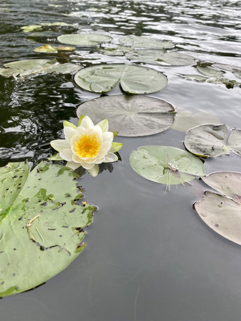
Nymphaea odorata/ Fragrant white waterlily in Lake Muskoka near Port Carling, ON. Not only is this Muskoka native gorgeous, the flowers are also edible!
Did you know a natural shoreline can:
Protect against erosion?
A natural shoreline is perfectly engineered to protect against erosion. Native vegetation along the shoreline strengthens the structural integrity of the land and prevents it from falling apart. The roots of the plants grip the earth and provide structure, and the foliage and leaves of the plant reduce erosion caused by rainfall and winds. Aquatic plants and buffer plants right along the edge of the shoreline also lessen the effects of wake hitting the shore.
Maintain or improve water quality?
Buffer plants and shoreline gardens reduce incidences of soil erosion, which has the added benefit of protecting fish habitats.
“One could think of it this way: waterfront plant buffers are like eyelashes to our lakes: they keep the grit and goo out”
www.muskokawatershed.org
Filter overland pollutants and absorb extra nutrients?
Vegetation along the shoreline not only helps slow the movement of surface runoff, but the roots of this vegetation also help absorb surface water – trapping excess nutrients and pollutants in the soil.
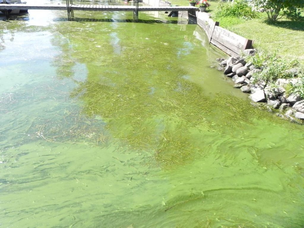
An excess of nutrients like phosphorus and nitrogen is one of the factors that can cause an algal bloom – much like how fertilizing your lawn causes it to grow faster. Given that the other main factors are weather related, keeping these nutrients at a reasonable level are the best defence cottagers have against algal blooms. There are many types of algae – an excess of any of these can be harmful to the aquatic ecosystem, but some types (like blue-green algae) can have dire consequences when it comes to our health and the health of our pets. Most other common types of algae are at their most harmful once they’ve died – they sink to the bottom of the lake and decompose, reducing the amount of oxygen available to fish and other aquatic organisms.
Consuming toxins from a blue-green algae bloom can include headaches, fever, diarrhea, abdominal pain, nausea, vomiting, and other more serious effects. It can also kill dogs and other animals. According to the Simcoe Muskoka District Health Unit, “people not on public water supplies should not drink surface water during an algal bloom, even if it is treated. In-home treatments such as boiling and disinfecting water with chlorine or UV and water filtration units do not protect from blue-green algal toxins.”
Blue-green algae does more than just threaten our health though – it also threatens our property values. Of particular note is the 2005 toxic algal bloom in Three Mile Lake in Muskoka, a lake which has had more than it’s fair share of blue-green algae related woes. This toxic bloom resulted in property values on Three Mile Lake dropping by about 25%. I guess that’s not much of a surprise to anyone after hearing about the health risks… but we should also mention how repulsive it can look and smell. According to former Township of Muskoka Lakes Mayor Susan Pryke, the worst hit areas of Three Mile Lake “looked like pea soup, with bits of algae floating in the water, sort of like chunks washing up on shore,” and smelled like “garbage that had been left sitting out too long.” Lovely.
Protect wildlife habitats, while ALSO reducing the number of geese that come on your property?
Throughout their lifecycles, the majority of our native Muskoka species depend on a healthy shoreline. The riparian zone (the area that lines the border of the water, with rich moist soils where diverse plant communities can grow) is used for sources of food and shelter, breeding, migration, and for rearing young. This area is also essential when it comes to preventing geese – geese are attracted to open spaces with easy access to the water, and they like to feed on short grass. If you have a goose problem then I’m willing to bet you probably have a grass lawn. A shoreline barrier of native Muskoka shrubs and tall vegetation can help deter them from hanging out on your property.
Moving into the water from the riparian zone, we enter the littoral zone – the submerged area of shoreline where the sunlight still penetrates through to the lake bottom. According to Muskoka Watershed Council, the littoral zone is “the richest natural environment that most of us will ever come into contact with,” with as much of 90% of the species in the lake either living in or passing through this zone. This area (and the aquatic plants and downed trees that it consists of) is responsible for providing oxygen to the lake, spawning areas, shallow protected nursery areas (for fish and amphibians), foraging areas, and hiding spots.
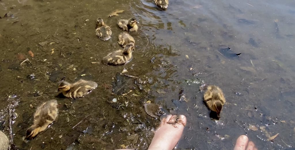
Ducklings foraging in shoreline debris. Mirror Lake, Muskoka, Ontario
Protect the economic benefits associated with tourism?
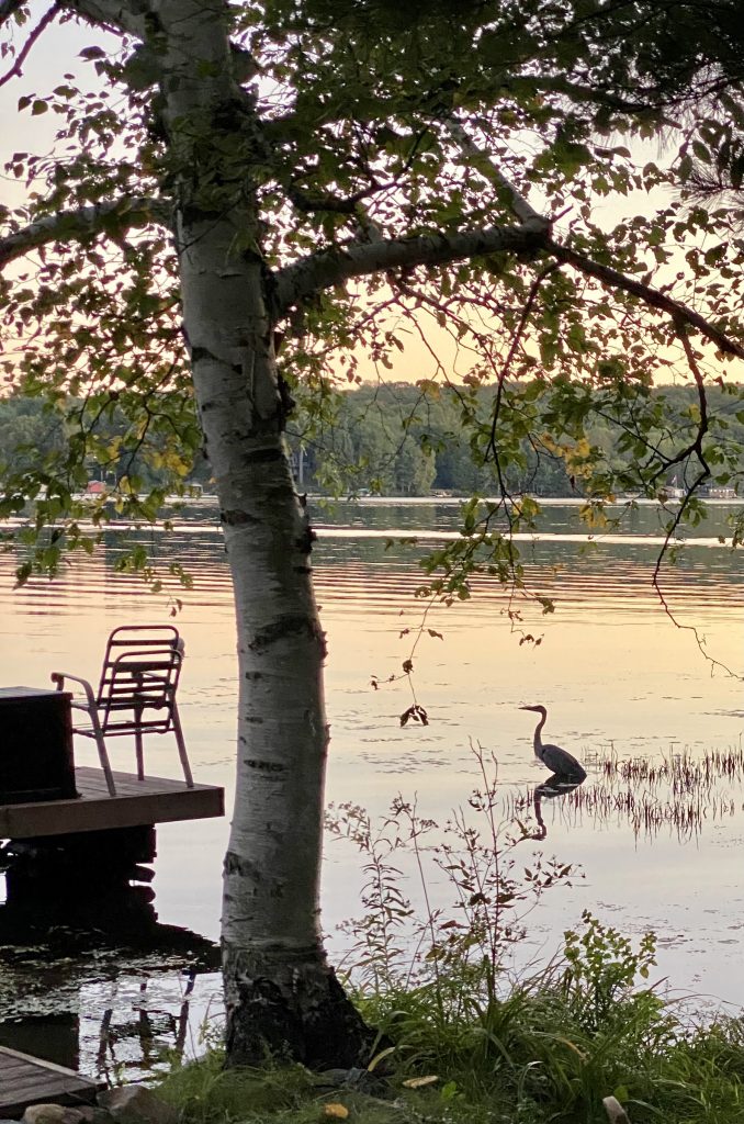
Nature is one of the major appeals of Muskoka! Wait to catch a sunset while you watch a Blue Heron fish nearby, a family of ducks float past, or any number of other native Muskoka species encounters. Or just enjoy floating in a lake that isn’t thick with potentially dangerous, smelly, pea-soup like blue-green algae… either way, if the health of our lakes isn’t protected it will result in major tourism-related economic losses down the line.
So, how do you naturalize your shoreline?
Getting started with naturalizing your shoreline doesn’t have to be some gargantuan effort – there are some very low effort ways you can get started on your journey to a healthier shoreline for your Muskoka cottage. Let’s look at a few ways you can help work towards a more natural Muskoka, in order of increasing difficulty…
Creating a no-mow zone near the shoreline to allow vegetation to re-establish
This one could not be easier – simply leave an area along your shoreline unmowed. It is recommended that you leave at least 10 feet, but any amount of shoreline buffer is better than nothing! Ideally you would also minimize the amount of entries you have into the water, leaving 75% of the length of your cottage shoreline to re-naturalize.
Bonus points if you follow this “no-mow” philosophy in the shallow water along your shoreline by using your dock as a bridge to get over the weedy shallow parts of the water rather than clearing the weeds to create a swimming area. That way you can still enjoy a clear area to enjoy the water, without harming this essential habitat.
A Great blue heron searching for a fishing spot in Lake Muskoka’s littoral zone
Placing or allowing woody debris to accumulate along the shoreline
Unless a fallen tree is a hazard to boats or swimmers, consider leaving it be! Not a lot of shoreline trees fall around the lake during a year… and clearing a bunch of them away at once can have disastrous consequences to the habitat they were supporting. By the way, submerged wood not only creates hiding and spawning spots for fish, it’s also a major food source for crayfish, aquatic insects, and small fish.
Active planting of native species
So, you’ve already begun to leave the strip of land nearest to your shoreline alone to re-naturalize… but why not help it along even more by planting some native grasses, plants, shrubs, and/or trees? This is also beneficial in terms of appearance – Muskoka has so many beautiful native plant species, so there’s no need to sacrifice the aesthetics of your cottage. People are often surprised how much they love the look of a naturalized shoreline garden.
Removal or “softening” of existing hard structures like retaining walls
While these hard structures may provide a temporary solution to erosion, they can cause damage to neighbouring properties. They can also eventually fail and damage the shoreline they were originally placed to protect.
Instead of removing these structures entirely, there is also the option of protecting the wall (and your shoreline) with softer measures such as planting buffer vegetation. In the case of rip rap, planting can be done between the rocks – the roots of the plants will help with structural integrity, and the foliage of the plants will help to protect against erosion from waves.
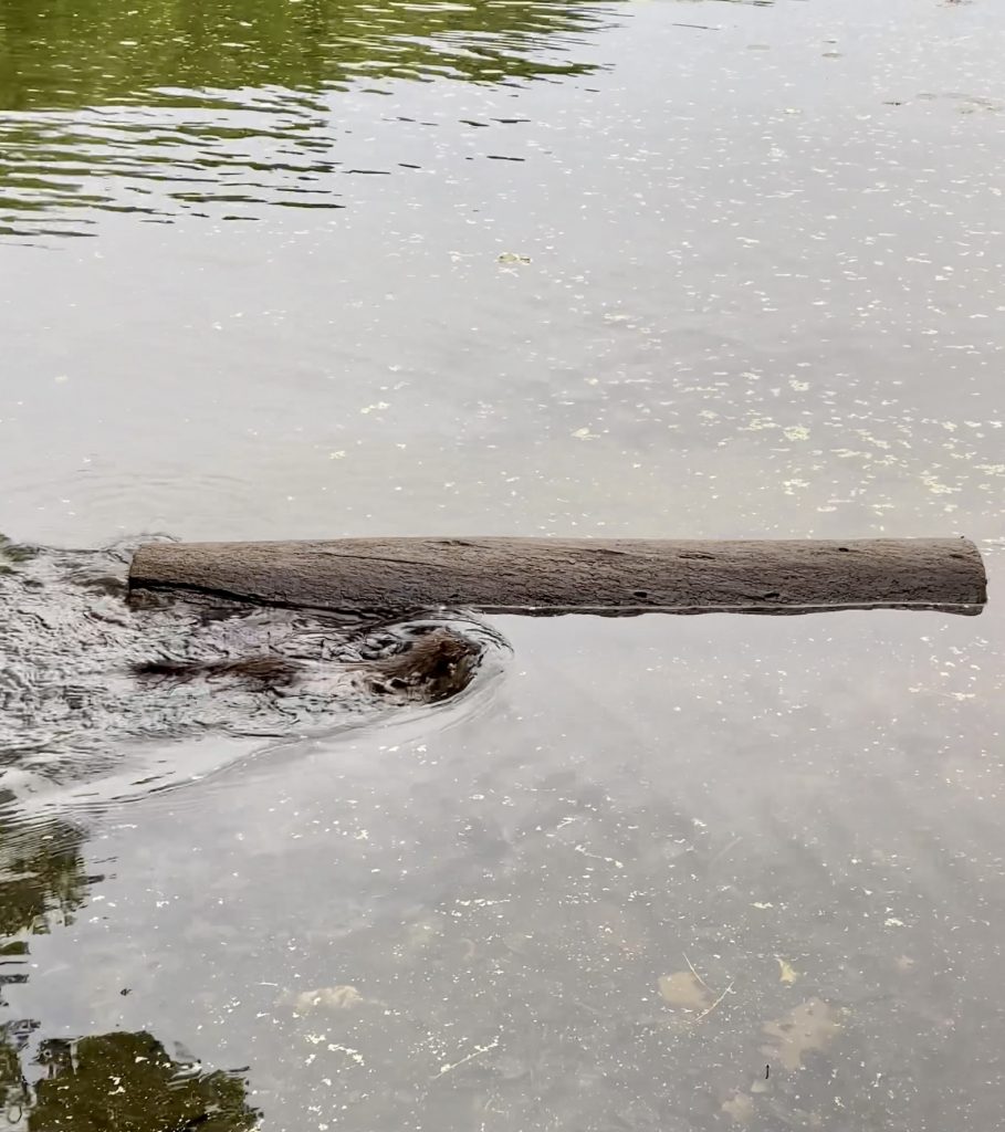
An American mink (Mustela vison) swims by carrying dinner. Lake Muskoka near Port Carling, ON.
As a volunteer, as well as being on the executive of the Muskoka Watershed Council, I am the videographer/video editor. This gives me a great opportunity to ensure that truly wonderful ideas and presentations are not lost after the words are spoken and the video projector is turned off. I record, edit and post to our YouTube channel, lectures and presentations at Muskoka Watershed Council events.
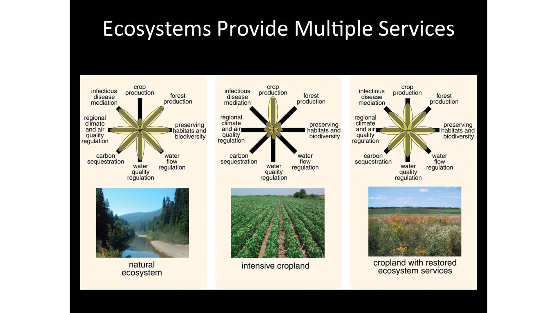
Understanding the relationship and implications of planning future multiple land use – bundling cottage use with agriculture for example – can help municipalities and land owners. This lecture is now available at the following link on Muskoka Watershed Council’s YouTube channel: Using Ecosystem Services to Design Multifunctional Landscapes. With a project still underway in La Vallée-du-Richelieu, Elena discusses how communities and scientists can get together to plan land use (bundling certain ecosystem services) while minimizing some negative environmental impacts.
The Question & Answer video is also available here.
The length of the “petals on the “flower” indicate the amount of the ecosystem service provided.
I just completed and posted another video of Robert Sandford from the University of Saskatchewan, at the 2014 Muskoka Summit on the Environment.
This is the question & answer session following his talk: Come Hell & High Water:
Scientific Truth and Economic Consequences In Hollywood Disaster Movies mentioned here.
Don’t be put off by the “grabber” title; this is an engaging and informative presentation on hydrologic change brought about by Climate Change and well worth your time.
As a volunteer, as well as being on the executive of the Muskoka Watershed Council, I am the videographer/video editor. This gives me a great opportunity to ensure that truly wonderful ideas and presentations are not lost after the words are spoken and the video projector is turned off. I record, edit and post to our YouTube channel, lectures and presentations at Muskoka Watershed Council events.
A highly engaging presentation, this one by Robert Sandford of the University of Saskatchewan, is the 1st lecture from the 2014 Muskoka Summit on the Environment . On June 8th and 9th I recorded the presentations over the two day summit. Broadcast, in part, by CBC Radio’s Ideas with Paul Kennedy, (here’s the 2014 Muskoka Summit CBC broadcast), these were world-class lectures, presented here in Muskoka. I am delighted to be able to ensure these are available to the world.
The Muskoka Lakes Association just sent the following update which includes a detailed report from the Ministry of Natural Resources.
Specific current levels are indicated for the following lakes: Tea Lake, Kawagama Lake, Lake of Bays, Wood Lake, Fox Lake, Mary Lake, Lake Rosseau, Lake Joseph, Lake Muskoka, Go Home Lake, Perry Lake, Doe Lake, Bernard Lake, Cecebe Lake, Ahmic Lake, Forest Lake, Dollars Lake, Crane Lake, Otter Lake and Oastler Lake.
Plus the current status of the river flows for the Big East, North Muskoka, South Muskoka, Oxtongue, Black, North Magnetawan, South Magnetawan, Magnetawan, Moon River, Musquash River and the Shawanaga River.
Here’s the message from the MLA and the linked .pdf below it.
To: steve@cottageinmuskoka.ca:
As promised, the MLA continues to monitor water levels throughout our catchment area.
The attached freshet update, issued yesterday afternoon, details current watershed conditions throughout Muskoka/Parry Sound.
We encourage you to review the attached document, which provides significant detail, and to take action to protect property if your residence is located in one of the affected areas.
The following was issued April 22, 2014 at 5:00 p.m.:
The Ministry of Natural Resources – Parry Sound District is advising area residents that a Flood Warning remains in effect.
Residents within the Parry Sound-Muskoka area are advised that some additional or prolonged flooding will occur within known flood-prone areas of many rivers and lakes. Recent warm air temperatures and rainfall has now accelerated the melting rate of the remaining snow pack with an increased runoff into local waterbodies. High water levels or flooding will occur over the next 24-48 hours within Lake Muskoka and the Moon River as part of the lower Muskoka River sub-watershed.
Residents are advised to keep a close watch on conditions, regularly check for updated messages and exercise caution around rivers and lakes as high water levels and flows continue. There is the potential for higher water levels and flows than what is currently being experienced.Residents may wish to take action to protect property in flood-prone or vulnerable areas. MNR is closely monitoring the weather and developing watershed conditions. Further updates to this Flood Warning will be issued as appropriate.
Description of Weather System
The current weather forecast through to Saturday April 26th is for daytime temperatures in the range of 5-10 degrees Celsius with near freezing nighttime temperatures. Today’s forecast is calling for a range of 3-30mm of rainfall Friday through Saturday.
Description of Current Conditions
A significant amount of the remaining snowpack has melted in recent days due to warm air temperature and rainfall, increasing the runoff into local river systems. A significant amount of snow still remains within local watersheds at higher elevation areas including the western slopes of Algonquin Park; the headwaters of some local river systems. Forecasted temperatures and rainfall will continue to melt the remaining snow pack with continued runoff into local river systems and lakes.
Expiry Date: This message will expire Friday April 25, 2014; 5:00 pm
Terminology: Notification Levels
WATERSHED CONDITIONS STATEMENT – FLOOD OUTLOOK: gives early notice of the potential for flooding based on weather forecasts calling for heavy rain, snow melt, high winds or other conditions
WATERSHED CONDITIONS STATEMENT – WATER SAFETY: indicates that high flows, melting ice or other factors could be dangerous for such users as boaters, anglers and swimmers but flooding is not expected.
FLOOD WATCH: potential for flooding exists within specific watercourses and municipalities
** FLOOD WARNING: flooding is imminent or occurring within specific watercourses and municipalities.
Contact Information
For more information please contact: Ministry of Natural Resources Parry Sound District: 705-646-5509 or 705-646-5531
A close watch on local conditions and weather forecasts from Environment Canada is recommended. Environment Canada bulletins can be found at http://weather.gc.ca/
The Surface Water Monitoring Centre public webpage can be found here: www.ontario.ca/flooding