Subject: Keep Muskoka Sparkling – Renew Your MLA Membership
Open Letter to Our Clients
When you close your eyes, can you hear it? The gentle lap of water against sun-warmed rock, the call of a loon across the bay, the scent of pine carried on a soft breeze. Muskoka has a way of weaving itself into our hearts, becoming not just a place, but a part of who we are.
That is why your membership in the Muskoka Lakes Association matters so deeply. Since 1894, the MLA has been the voice and the guardian of this shimmering paradise, protecting our water quality, standing watch over our precious shorelines, and celebrating the timeless joy of cottage life.
Your 2025 membership was gifted to you, and I truly hope you’ve felt the connection it brings, because updates keep you informed, events gather us together, and our community cares as much about Muskoka as you do.
Now, as the season turns, I warmly invite you to renew your membership for $150 and continue standing with us in protecting all that makes Muskoka magical, the sparkling lakes, the whispering pines, the rugged granite, and the laughter of families at the water’s edge.
Renewing is more than a transaction, it’s a declaration: I belong here. I care about this place. I will help protect it for generations to come.
Your renewal keeps Muskoka’s waters clean, our traditions alive, and our voices strong.
Please take a moment today to renew your membership at www.mla.on.ca.
Thank you, from my heart, for being part of this story. Together, we keep Muskoka shining.
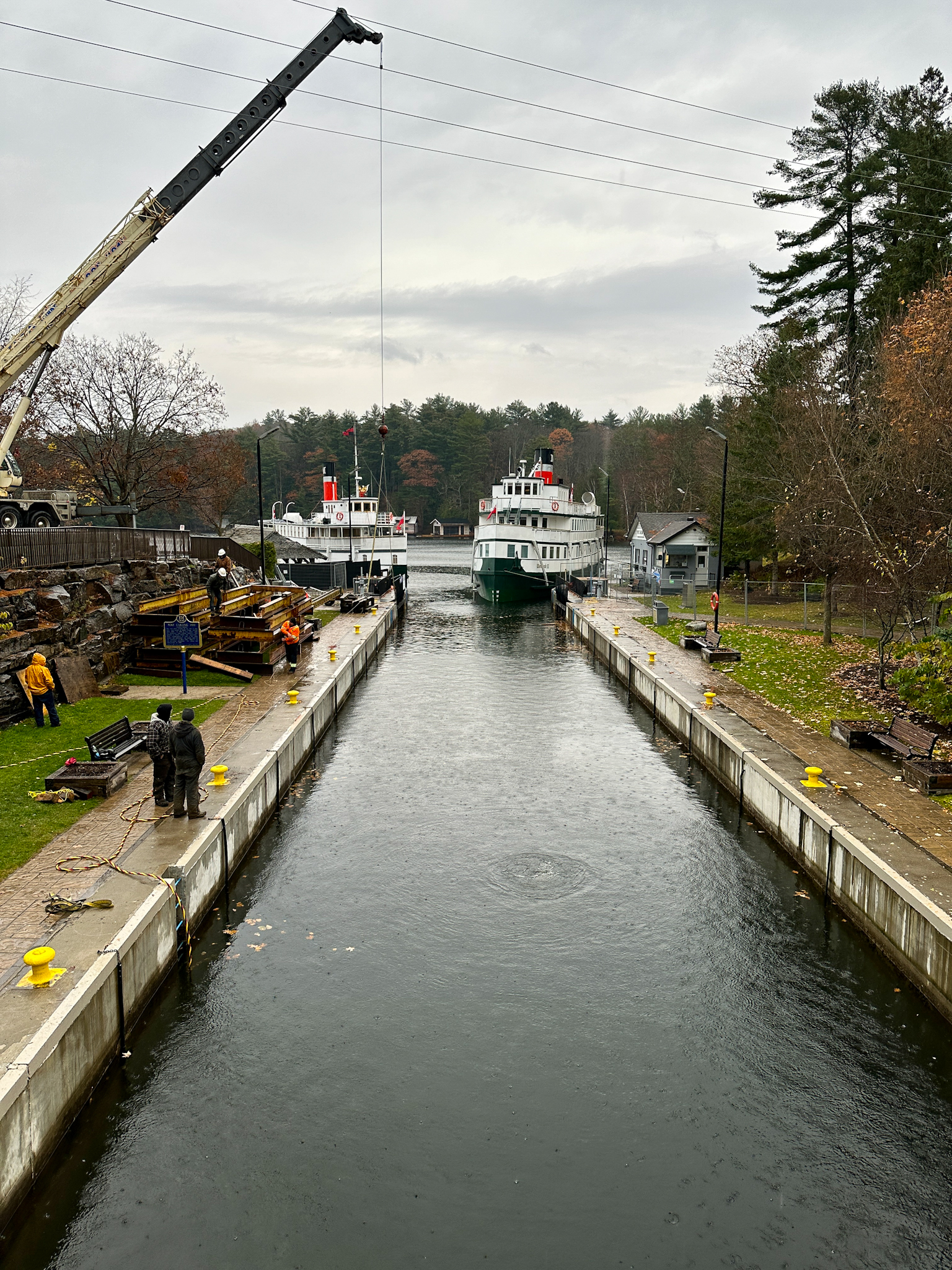
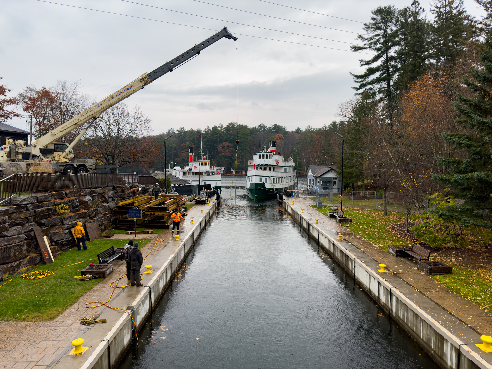
Excitement is in the air as Muskoka enthusiasts and steamship lovers celebrate the completion of the dry docking process for the iconic Muskoka Steamships, Wenonah II and RMS Segwun. As of November 7th, the large lock at Port Carling has reopened, signaling the triumphant return of these historic vessels to the waters of Lake Muskoka, Lake Rosseau, and Lake Joseph.
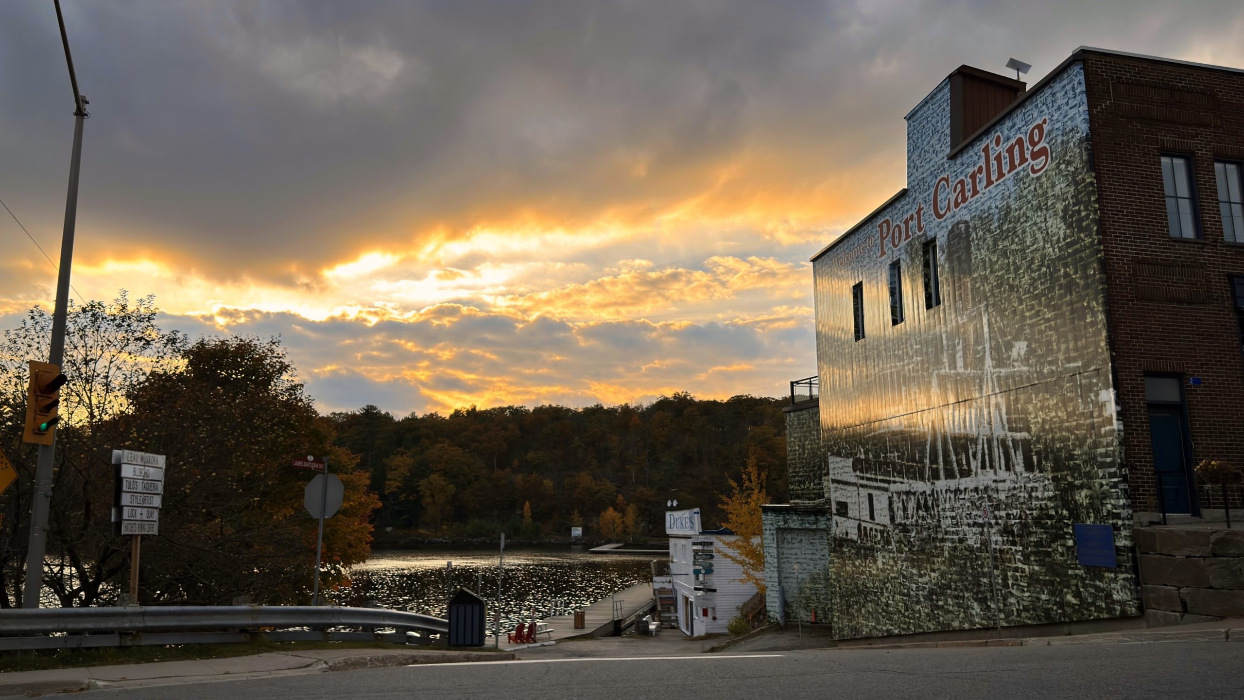
RMS Segwun and Wenonah II at the Port Carling Lock, November 6, 2023.
Dry Docking at the Port Carling Locks
The dry docking process, which takes place at the Port Carling Lock, ensures the safety and preservation of the Wenonah II and RMS Segwun. This essential maintenance, mandated by Transport Canada, involved thorough inspections, repairs, and care for every intricate detail of these floating pieces of history. The dry docking process offered a rare opportunity for enthusiasts to witness these majestic vessels out of the water, showcasing the craftsmanship that keeps them afloat.
Reopening of the Port Carling Lock
As of today (November 9th, 2023), the Port Carling large lock, situated on James Bartleman Island, has reopened, welcoming the Muskoka Steamships back to the lakes. This reopening not only marks the successful completion of the dry docking process but also signifies the beginning of a new chapter for these vessels as they embark on another season of journeys through the picturesque Muskoka Lakes.
Celebrating a Tradition of Elegance
The Wenonah II and RMS Segwun, with their rich histories dating back to the late 19th century, continue to be cherished symbols of Muskoka’s elegance and timeless allure. The completion of the dry docking process ensures that their legacy endures, captivating both locals and visitors with the magic of steamship travel.
With the large lock now reopened, Muskoka Steamship enthusiasts can look forward to upcoming cruises and experiences aboard these historic vessels. Whether it’s a leisurely trip on Lake Muskoka, a captivating journey on Lake Rosseau, or an exploration of the serene waters of Lake Joseph, the Muskoka Steamships promise unforgettable moments against the backdrop of Muskoka’s stunning scenery.
RMS Segwun and Wenonah II at the Port Carling Lock, November 6, 2023.
Boater? Here’s What to Expect
The large lock in Port Carling is now once again available for boaters to travel through. It will soon close for the season (date pending), but the small self-serve lock will still be available for boaters to travel through.
As the large lock at Port Carling swings open once again, Muskoka celebrates the successful completion of the dry docking process for the Wenonah II and RMS Segwun. These beloved steamships, meticulously cared for and preserved, are ready to set sail on another season of history and elegance. Join us in welcoming them back to the Muskoka Lakes and creating new memories aboard these timeless vessels. The journey continues, and the legacy of Muskoka Steamships sails on!
Muskoka, Ontario, is known for its breathtaking landscapes, pristine lakes, and a rich history of leisurely exploration. One iconic feature of Muskoka is the Muskoka Steamships, which include the Wenonah II and the RMS Segwun. These vintage vessels have been sailing the Muskoka Lakes for generations, offering a unique and timeless experience for both residents and visitors.
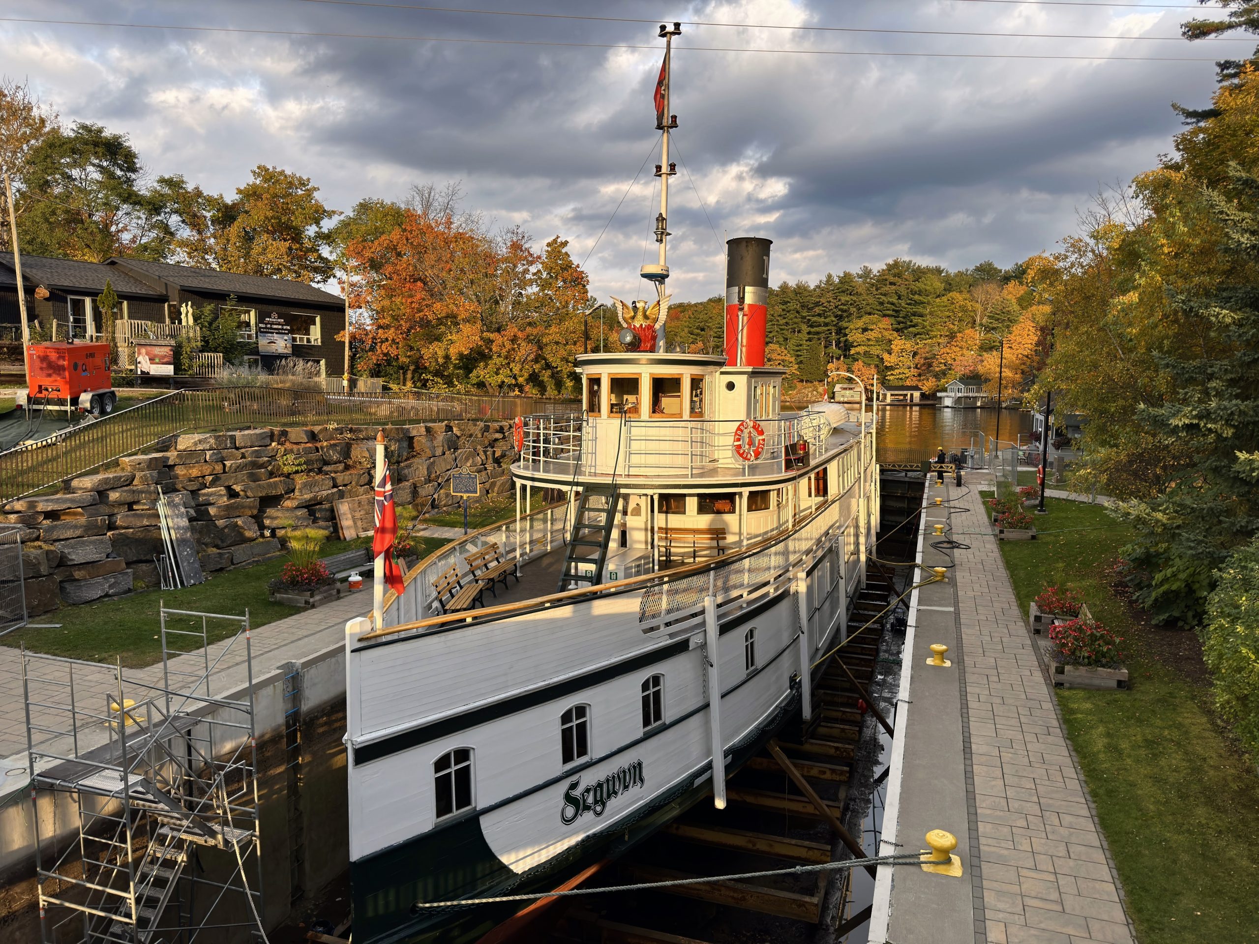
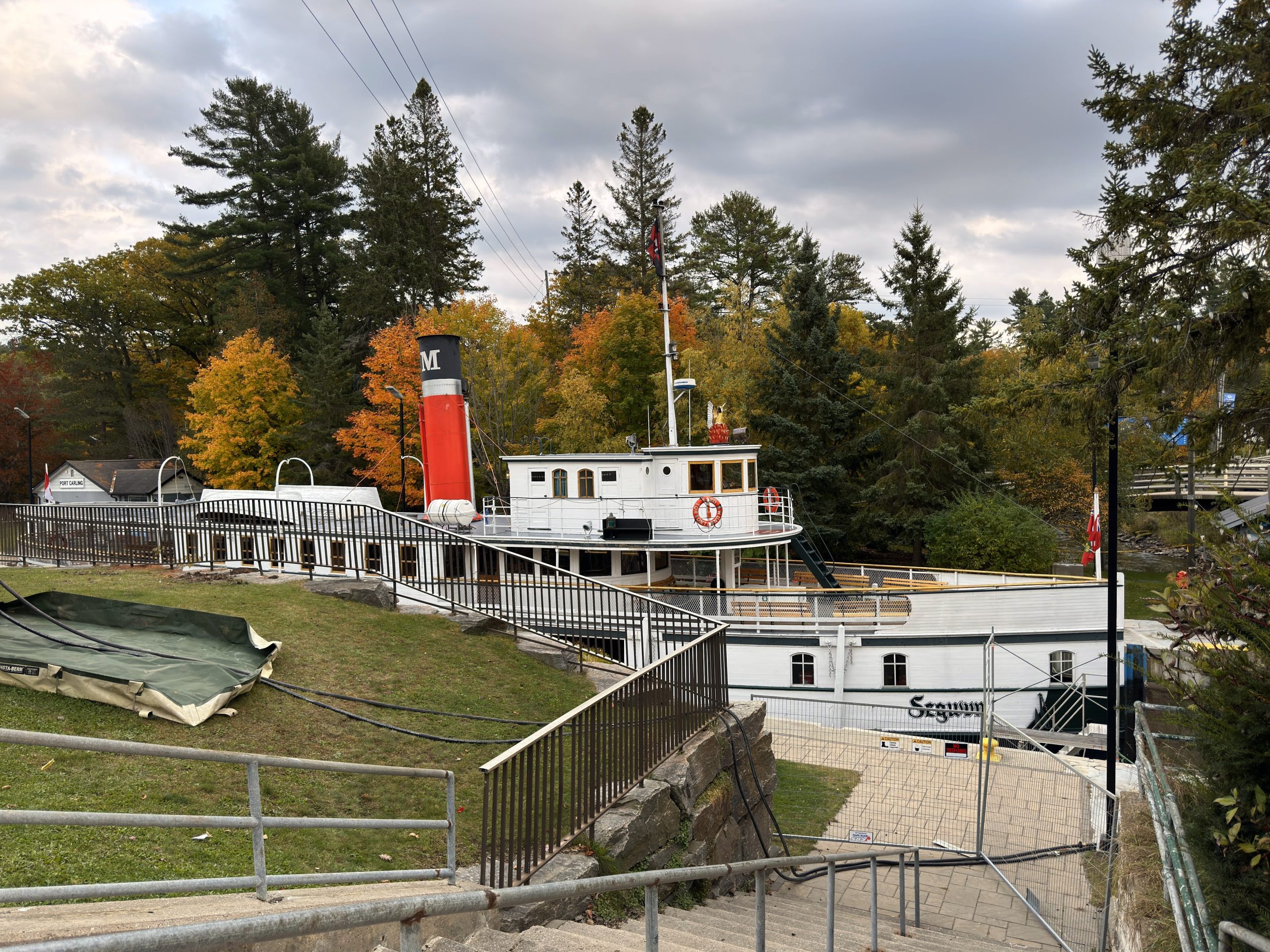
The RMS Segwun dry docked at the large lock in Port Carling, Muskoka Lakes, Ontario. October 19, 2023.
But have you ever wondered why these charming steamships periodically dry dock at the Port Carling lock? In this blog post, we’ll dive into the fascinating world of Muskoka Steamships, their significance, and the essential Transport Canada mandated maintenance and inspection that takes place at this strategic location.
Muskoka Steamships: A Legacy of Elegance
The Wenonah II and RMS Segwun are more than just boats; they are floating pieces of history. The RMS Segwun, for instance, was built in 1887, making it one of the oldest operating steamships in North America. These vessels offer an authentic glimpse into Muskoka’s past and provide an unforgettable experience to those who step aboard.
The Importance of the Port Carling Lock
The RMS Segwun dry docked at the large lock in Port Carling, Muskoka Lakes, Ontario. October 19, 2023.
To ensure the safety and longevity of these cherished vessels, Transport Canada mandates regular maintenance and inspection. The Port Carling lock, located on James Bartleman Island, where Lake Muskoka meets Lake Rosseau and connects to Lake Joseph, stands as the only place that can accommodate their specific needs. This strategic location serves as the indispensable hub for servicing and maintaining the Muskoka Steamships. This process should be completed around November 7th.
This also provides a great opportunity for inspection and maintenance of the large lock!
Port Carling Small Lock – Standing By!
During the ~ month long closure of the large lock, the small self-serve lock is still operational to allow passage between Lake Rosseau and Lake Muskoka.
A Rare Opportunity to Witness the Steamships Out of Water
The dry docking process at the Port Carling lock provides a remarkable and rare opportunity for enthusiasts and curious onlookers to witness these historic steamships out of the water. It’s a chance to see the intricate details of these vessels, which are typically hidden beneath the surface, and gain a deeper appreciation for their craftsmanship.
The mandated maintenance and inspection processes are critical to ensuring the safety and functionality of these historic vessels. They include checks on the steam engines, hull, and other essential components. These activities are conducted with the utmost care and expertise to preserve the charm and reliability of the steamships.
The Muskoka Steamships, Wenonah II and RMS Segwun, are living pieces of history that offer a timeless and elegant experience on the Muskoka Lakes. The Port Carling lock plays a vital role in preserving these iconic vessels by providing the only location that can accommodate their specific needs for Transport Canada mandated maintenance and inspection. As they continue to navigate the beautiful waters of Muskoka, the legacy of the steamships lives on, enchanting new generations with a taste of the past.
The iconic Port Carling Wall, located diagonally across the intersection from the Port Carling Lock.
So, the next time you see the Muskoka Steamships cruising on Lake Muskoka, Lake Rosseau, or Lake Joseph, you’ll have a deeper appreciation for the care and maintenance that keeps these pieces of history afloat. Hopefully you had the chance to see them out of the water during the dry docking process, but if not don’t forget to check out our instagram for a closer look!
There are a few things that contribute to flooding in Muskoka, which we mostly experience along the Muskoka River Watershed – one of four watersheds in Muskoka. This watershed includes the Muskoka River, Moon River, Lake Muskoka, Lake Rosseau, and Lake Joseph, among others.
Duke’s (Duke boats) in Port Carling, Muskoka, ON. April 21, 2023.
Building location
The first major factor is where we’ve built cottages and homes. Many of the builds in the areas that experience the most flooding in Muskoka (Muskoka River, Lake Muskoka, and Moon River) are built on floodplains. In fact, builders on Lake Muskoka have started to build with that in mind… and not just by raising docks and boathouses! I saw a post made by Corbin Patten Designs on Instagram recently where they had included a raised section in a boathouse to keep a beer fridge safe during future floods.
If you don’t know what a floodplain is, it’s an area adjacent to a river or other watercourse that is susceptible to flooding. Floodplains are typically low-lying and flat, making them ideal for the slow accumulation of water during periods of high precipitation or snow melt. While these areas provide important ecological functions like natural flood control, water purification, and habitat for fish and wildlife, unwittingly building on a floodplain can be disastrous. Ensure that you are checking floodplain maps before you build or buy!
Flooding in Muskoka can be caused by a variety of environmental factors, including the amount of snow pack here and in Algonquin, the speed of thaw, and the level of precipitation. The Muskoka River watershed has its headwaters in Algonquin, and the amount of snowpack there significantly affects flooding here. When there is an above average amount of snow pack in Algonquin, it can lead to a larger volume of water entering Muskoka’s waterways during the spring thaw. The speed of thaw is also crucial in determining the severity of flooding in Muskoka. If temperatures rise too quickly, the snow and ice can melt too rapidly, overwhelming the local waterways and causing flooding. Finally, the amount of precipitation during the spring months can also contribute to flooding, as heavy rains can cause rivers and lakes to overflow their banks. All of these factors must be taken into account when predicting and preparing for potential flooding events in Muskoka.
Limitations to MNRF control
Okay, and here’s a reason that not many people seem to know… the dams along the Muskoka River Watershed are NOT flood control structures! The MNRF can draw down water to prepare for potential flooding, but beyond a certain point there’s nothing they can do to stop it. Here’s an excerpt from the 2019 Ontario Flood Report:
“It must be emphasised that dams in central Ontario, including those in the Muskoka River watershed, are not flood control structures. Flood control structures require a large lake or reservoir and associated drawdown capacity to store or hold back flood waters. Analyses have confirmed that lakes in the Muskoka River watershed that are regulated by dams have a limited capacity to drawdown water to affect flooding, and during periods of large volume rapid runoff, the available drawdown capacity is insufficient to reduce peak flood water levels. In this sense, the greater the magnitude of the flood event, the less ability the MNRF has on affecting or mitigating flooding through operation of its dams. Once the dams are fully open, the MNRF does not have the ability to increase the rate of flow, as it is then based on the amount of water in the system and the natural rate of flow and elevation as it moves through the wide-open dam sluice ways.“
There’s also a limit to how much they can draw down the water levels which has nothing to do with the dams, and more to do with the creatures we share Muskoka’s waterways with. Drawing down water levels can have a significant impact on lake trout spawning. Lake trout are a cold-water fish species that require specific water temperature and oxygen levels to successfully spawn.
In many cases, lake trout will spawn in shallower water nearer to the shoreline than their usual habitat. However, if water levels are drawn down too quickly or too far, the shallow spawning beds may become exposed to the air, causing the eggs to dry out and die. Additionally, sudden changes in water levels can cause currents and turbulence that can dislodge the eggs from the spawning beds, reducing the chances of successful hatching and survival. As such, water managers must carefully consider the impact of drawing down water levels on lake trout spawning and take steps to mitigate any negative effects.
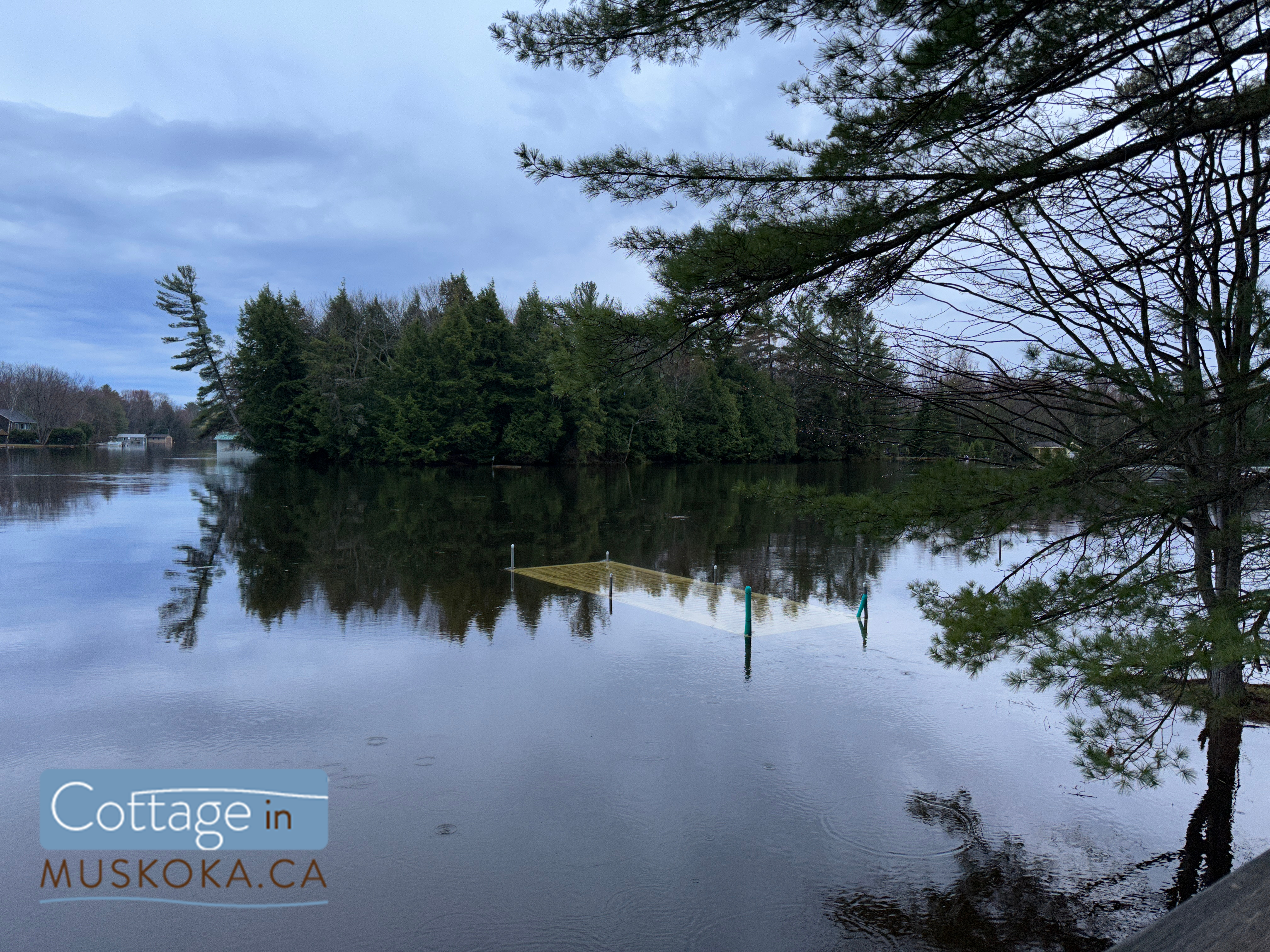
A flooded dock next to Patterson-Kaye Resort on Lake Muskoka in Bracebridge, Muskoka, ON. April 21, 2023.
So, what can we do about flooding in Muskoka?
Well, here’s what the Ministry of Natural Resources and Forestry can do:
Muskoka River Water Management Plan (MRWMP)
The MNRF is responsible for managing the water resources in Muskoka and has developed a comprehensive water management plan to mitigate the impact of flooding events and protect the local ecosystem.
The plan includes a range of measures, such as monitoring water levels and flows, managing dams and water control structures, and providing timely warnings to communities in the event of flooding. You can check out the full Water Management Plan here.
The MNRF also works with other government agencies, local municipalities, and community groups to develop and implement best practices for managing water resources in the region. These practices include promoting the use of permeable surfaces to reduce runoff, and restoring wetlands to provide natural flood control. Overall, the MNRF’s water management plan aims to balance the needs of the local ecosystem with the social and economic benefits of water use in the region.
And as for us?
Be prepared
Expect flooding if you cottage or live in certain areas – in particular the Muskoka River, Lake Muskoka, and Moon River, or on any floodplain. Prepare your property, dock, and boathouse when you close your cottage in the winter. Sign up for our newsletter – you’ll be reminded when the time comes, and you’ll be shown exactly how to close your cottage and prepare for potential spring flooding. I’ll be sure to add an additional post about bracing for a flood before the spring 2024 flood season in Muskoka.
Use a local real estate agent
Not only do we know what areas flood (and see it firsthand), we’ll make sure to review floodplain maps as part of our due diligence – something that a Toronto real estate agent wouldn’t necessarily think to do. I would not be the first person you would ask about problematic condo buildings in the city or the areas of Toronto with the best walkability, and they should not be your trusted source for information about Muskoka.
Continue monitoring the situation when the water level begins to decline
The first sign of receding water levels is not the time to stop monitoring the situation.
First of all, high levels of precipitation, additional snowpack melting and adding water to the watershed, and dams flows being reduced to relieve flooding further down the watershed can all cause the levels to start rising again.
But here’s the bit everyone seems to forget – let’s say the water level was high enough that your boat is floating around in your boathouse. I’m sure you’ve secured it carefully, and removed anything that could damage it. But what happens when the water level drops? You need to make sure the boat makes it back into the slip. Not only can you damage your boat and the boathouse, but how would you ever move it again if it ends up out of the water? A jetski could be put back in the water with help from a few friends… good luck doing that with a boat!
You also need to watch the water levels if you’ve tied your boat off somewhere higher up in the boathouse. Obviously you can’t just make the ropes long enough to compensate, because you don’t want your boat smashing around in there. But what happens if you’ve tied it normally and the water level goes down beyond the length of rope you’ve used? I’ll tell you what – damage! Time to practice your sailing knots. We’ll teach you in our flood coverage if the water level starts to get high enough.
Stay up-to-date
You can check current flood information (warnings and watches by area) from the Government of Ontario here.
We posted daily flood update stories on our Instagram this year, with up-to-date photos and location information, plus alerts about flood warnings, updates from the township, real time water level graphs from multiple water bodies in Muskoka, and other relevant info. We also stopped by a number of cottages to check on them for their owners. Follow us on instagram here to be kept up-to-date about flooding in Muskoka next time around.
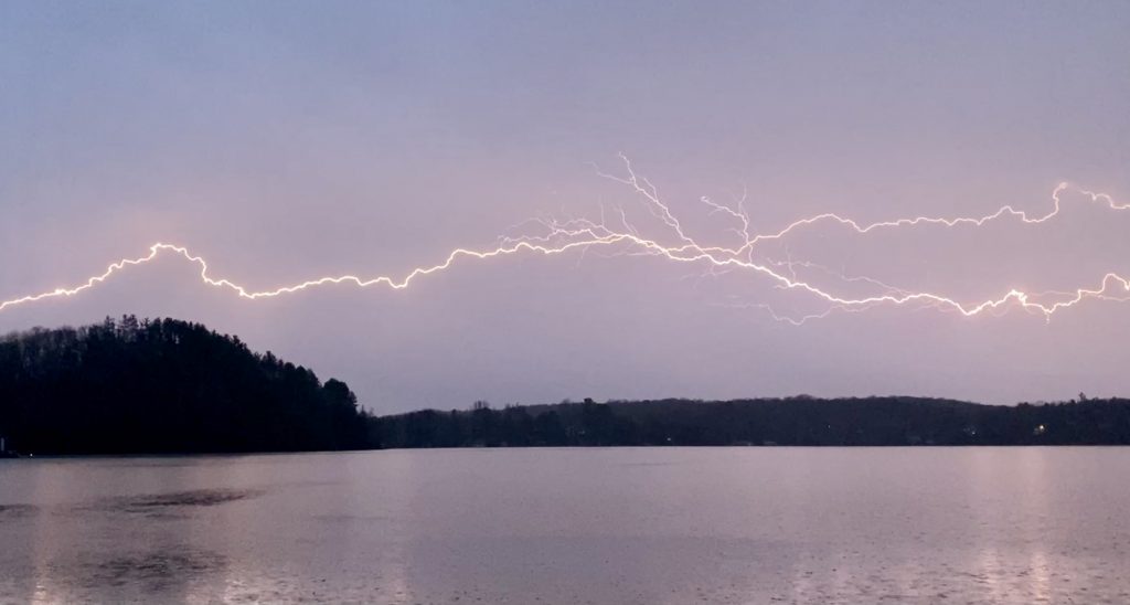
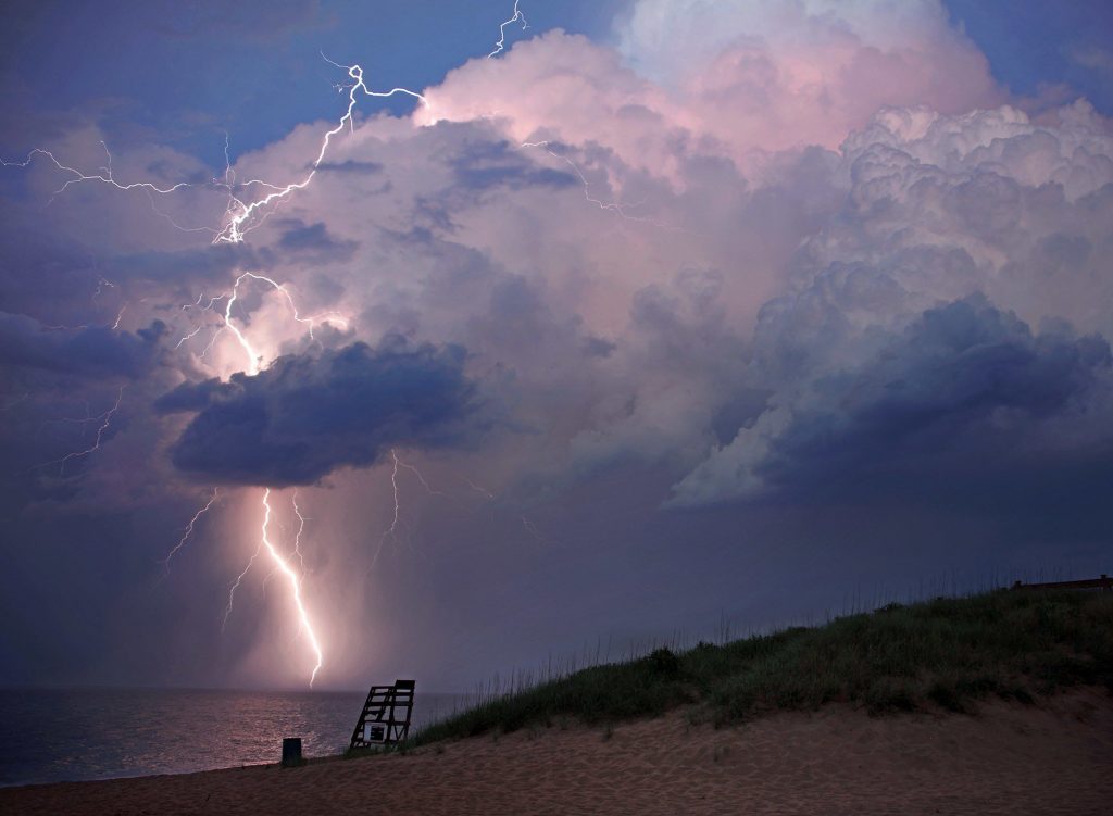
I’ve been loving hobby photography lately, but I’d never thought to capture a lightning storm before. As a child I remember being told that lightning came up through the ground (which is only partially true), so I was surprised to check my pics and see the horizontal lightning bolts.
Horizontal lightning bolt over Lake Muskoka in Port Carling, ON.
First: a short explanation of how lightning works, then I’ll explain what I learned about my horizontal lightning strikes!
Lightning is all about the charges – nature always wants to find equilibrium. It’s a natural static discharge where different areas of the atmosphere equalize in charge. Think of it like when you get a static shock from something – it’s the same process taking place.
The most common type of lightning is cloud-to-ground (CG). Generally CG is negatively charged. This channel of negative charge, called a stepped leader, is invisible to the human eye. When it approaches the ground, positively-charged “streamers” reach up to meet it – which explains the “lightning comes from the ground” misconception! These streamers tend to travel up through tall objects like trees, and when they reach the oppositely-charged leader electric current begins flowing – which is why you’re supposed to avoid standing near trees or tall objects during storms.
Cloud-to-ground lightning via lightningmaster.com
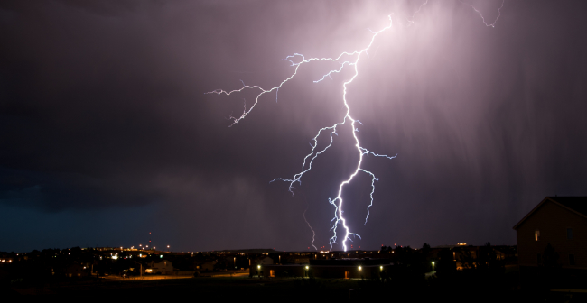
Occasionally, an exceptional amount of positive charge builds up in the upper levels of the cloud. This too must be balanced out, and since the lightning has a longer way to travel it is much more powerful. Usually these bolts travel vertically to the ground, but because of the high difference in electrical potential they can also travel horizontally before going to the ground. This means that these positive cloud-to-ground lightning bolts can strike from a blue sky many miles away from the storm – a “bolt from the blue.” Since positive lightning has higher peak currents and longer continuing currents, it is capable of heating surfaces to higher levels… which also makes it the type of lightning most likely to start a forest fire.
Positive cloud-to-ground lightning, via the Washington Post
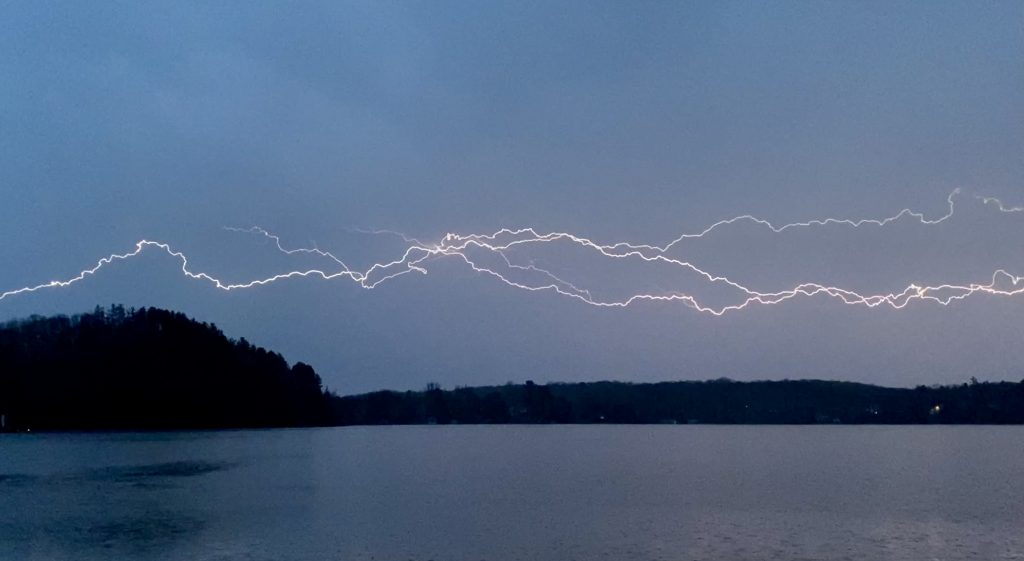
So anyway, onto our horizontal lightning strikes! The explanation for these bright horizontal strikes is actually pretty simple – differently-charged areas in the atmosphere are simply seeking equilibrium, this time it happens to be two clouds with opposing charges (cloud-to-cloud lightning). As we learned earlier, clouds can be either negatively or positively charged, and nature always seeks equilibrium.
Cloud-to-cloud lightning over Lake Muskoka in Port Carling, ON
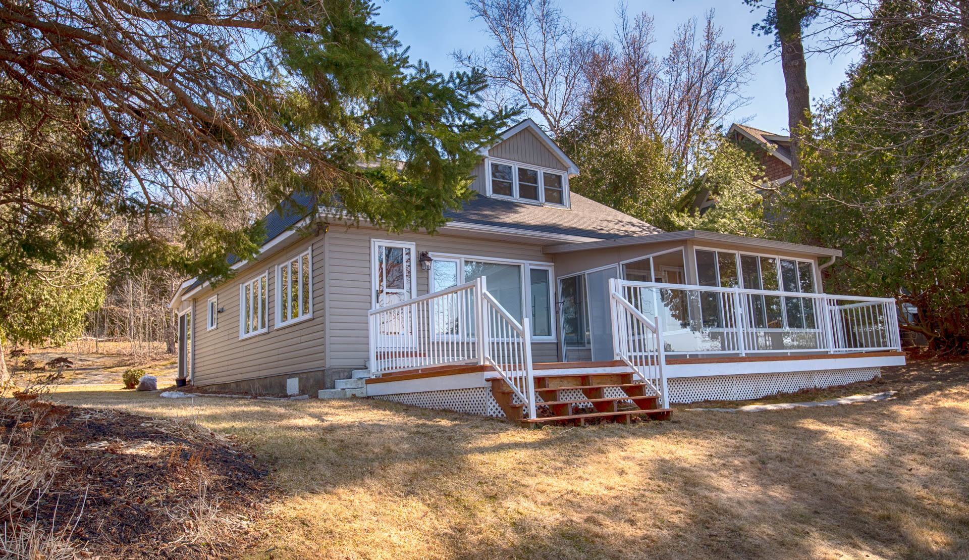
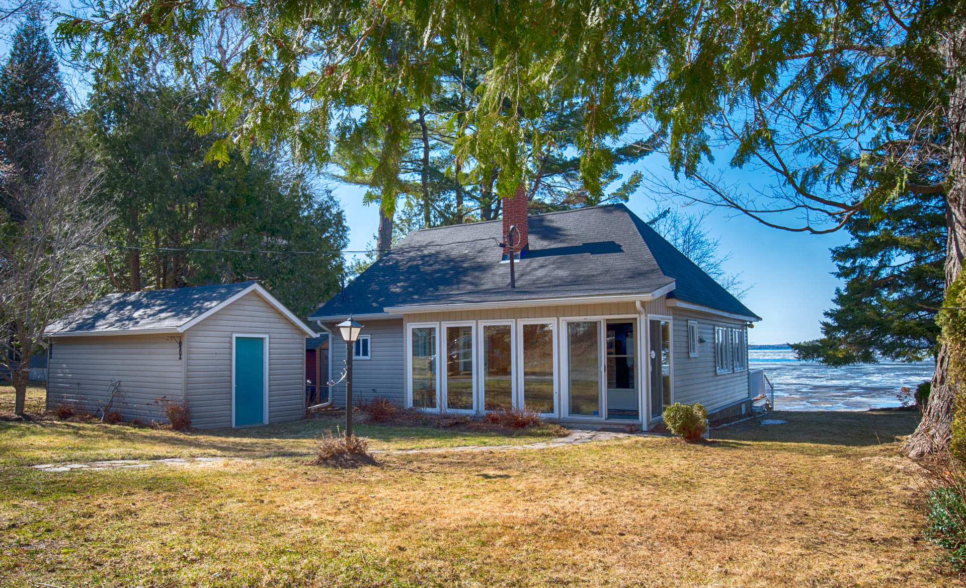
Cottage in Muskoka for sale, Lake Muskoka (Muskoka Beach) – Beautifully kept, super-clean, three bedroom, one bath cottage for sale on level lot in Muskoka Beach area.
Muskoka Beach cottage for sale
The Muskoka Beach community on Lake Muskoka is known for its shallow, perfect hard-sand bottom, beautiful views and gorgeous sunsets. This four season cottage has municipal water and has been meticulously maintained. There is super-easy access by road to this very level lot; just 5 minutes to Gravenhurst.
Due in no small part to the wonderful sand bottom and the gorgeous views, cottages on Muskoka Beach sell very quickly and this one is very affordable at $749,900.
Every once in a while there is a very special place that speaks to that special cottager who loves Muskoka history. This place was built in the thirties, in Muskoka Beach Village and although it has been very well preserved, it still has all the original features that made cottaging so appealing in the past century.
The cottage is white clapboard, with an oversized Muskoka Room, for starters. You can see the water through the trees, while sitting on the porch. The walls are fir lined, and the rooms are spacious. The original stone fireplace is so appealing, and there are pristine oil lamps attached to the walls.
The bathroom is bright and gleaming and the kitchen is large. If you listen carefully, you can hear the rabble of meal making, and the laughter of a bygone era.
The carefree days of enjoying Olde Muskoka don’t have to be over. Purchase this property today. It stands steadfast on a double lot with municipal water and the potential for municipal sewage. It is currently three season, but would make a great place to live year ’round with some renovations.
The beach is a few steps away. This cottage is not directly on the waterfront (but not across a road) , and therefore the taxes are low.
The deeded access is fewer than a dozen steps to a wide sand beach, lovely swimming and some of the best views Lake Muskoka has to offer. And you thought that Lake Muskoka was just out of your reach. Asking a mere $360,500.00
Here’s an opportunity to have your own Muskoka cottage on such a large level, Lake Muskoka waterfront property, and for much less than you would expect.
Sought after Walker’s Point locale with over 600 feet of frontage, ready for your …
The Muskoka Lakes Association just sent the following update which includes a detailed report from the Ministry of Natural Resources.
Specific current levels are indicated for the following lakes: Tea Lake, Kawagama Lake, Lake of Bays, Wood Lake, Fox Lake, Mary Lake, Lake Rosseau, Lake Joseph, Lake Muskoka, Go Home Lake, Perry Lake, Doe Lake, Bernard Lake, Cecebe Lake, Ahmic Lake, Forest Lake, Dollars Lake, Crane Lake, Otter Lake and Oastler Lake.
Plus the current status of the river flows for the Big East, North Muskoka, South Muskoka, Oxtongue, Black, North Magnetawan, South Magnetawan, Magnetawan, Moon River, Musquash River and the Shawanaga River.
Here’s the message from the MLA and the linked .pdf below it.
To: steve@cottageinmuskoka.ca:
As promised, the MLA continues to monitor water levels throughout our catchment area.
The attached freshet update, issued yesterday afternoon, details current watershed conditions throughout Muskoka/Parry Sound.
We encourage you to review the attached document, which provides significant detail, and to take action to protect property if your residence is located in one of the affected areas.
The following was issued April 22, 2014 at 5:00 p.m.:
The Ministry of Natural Resources – Parry Sound District is advising area residents that a Flood Warning remains in effect.
Residents within the Parry Sound-Muskoka area are advised that some additional or prolonged flooding will occur within known flood-prone areas of many rivers and lakes. Recent warm air temperatures and rainfall has now accelerated the melting rate of the remaining snow pack with an increased runoff into local waterbodies. High water levels or flooding will occur over the next 24-48 hours within Lake Muskoka and the Moon River as part of the lower Muskoka River sub-watershed.
Residents are advised to keep a close watch on conditions, regularly check for updated messages and exercise caution around rivers and lakes as high water levels and flows continue. There is the potential for higher water levels and flows than what is currently being experienced.Residents may wish to take action to protect property in flood-prone or vulnerable areas. MNR is closely monitoring the weather and developing watershed conditions. Further updates to this Flood Warning will be issued as appropriate.
Description of Weather System
The current weather forecast through to Saturday April 26th is for daytime temperatures in the range of 5-10 degrees Celsius with near freezing nighttime temperatures. Today’s forecast is calling for a range of 3-30mm of rainfall Friday through Saturday.
Description of Current Conditions
A significant amount of the remaining snowpack has melted in recent days due to warm air temperature and rainfall, increasing the runoff into local river systems. A significant amount of snow still remains within local watersheds at higher elevation areas including the western slopes of Algonquin Park; the headwaters of some local river systems. Forecasted temperatures and rainfall will continue to melt the remaining snow pack with continued runoff into local river systems and lakes.
Expiry Date: This message will expire Friday April 25, 2014; 5:00 pm
Terminology: Notification Levels
WATERSHED CONDITIONS STATEMENT – FLOOD OUTLOOK: gives early notice of the potential for flooding based on weather forecasts calling for heavy rain, snow melt, high winds or other conditions
WATERSHED CONDITIONS STATEMENT – WATER SAFETY: indicates that high flows, melting ice or other factors could be dangerous for such users as boaters, anglers and swimmers but flooding is not expected.
FLOOD WATCH: potential for flooding exists within specific watercourses and municipalities
** FLOOD WARNING: flooding is imminent or occurring within specific watercourses and municipalities.
Contact Information
For more information please contact: Ministry of Natural Resources Parry Sound District: 705-646-5509 or 705-646-5531
A close watch on local conditions and weather forecasts from Environment Canada is recommended. Environment Canada bulletins can be found at http://weather.gc.ca/
The Surface Water Monitoring Centre public webpage can be found here: www.ontario.ca/flooding