There are a few things that contribute to flooding in Muskoka, which we mostly experience along the Muskoka River Watershed – one of four watersheds in Muskoka. This watershed includes the Muskoka River, Moon River, Lake Muskoka, Lake Rosseau, and Lake Joseph, among others.

Building location
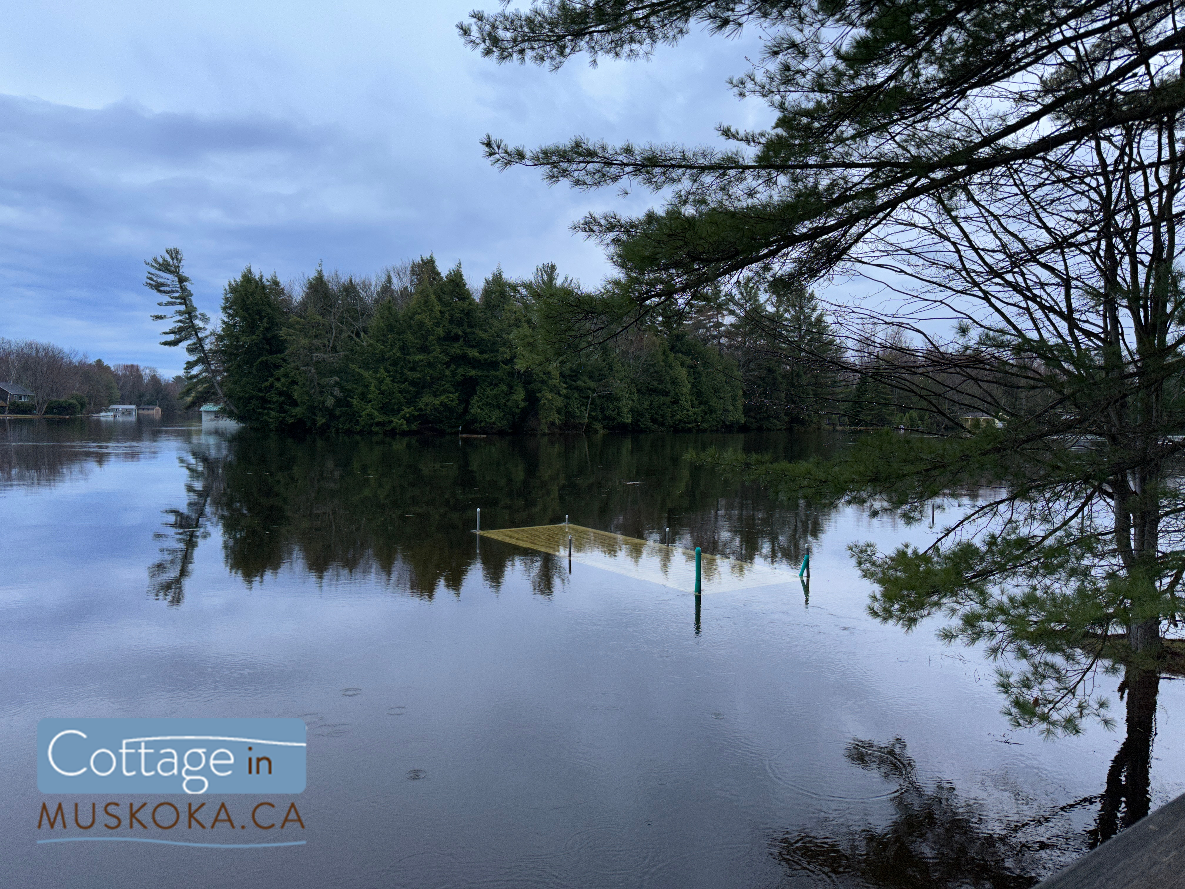
The first major factor is where we’ve built cottages and homes. Many of the builds in the areas that experience the most flooding in Muskoka (Muskoka River, Lake Muskoka, and Moon River) are built on floodplains. In fact, builders on Lake Muskoka have started to build with that in mind… and not just by raising docks and boathouses! I saw a post made by Corbin Patten Designs on Instagram recently where they had included a raised section in a boathouse to keep a beer fridge safe during future floods.
If you don’t know what a floodplain is, it’s an area adjacent to a river or other watercourse that is susceptible to flooding. Floodplains are typically low-lying and flat, making them ideal for the slow accumulation of water during periods of high precipitation or snow melt. While these areas provide important ecological functions like natural flood control, water purification, and habitat for fish and wildlife, unwittingly building on a floodplain can be disastrous. Ensure that you are checking floodplain maps before you build or buy!
Here’s a link to a floodplain map from Muskoka Geohub! Or just leave the pre-purchase check to your real estate agent, I know for a fact they always check (because Catharine and I are your realtors, right?).
Environmental factors
Flooding in Muskoka can be caused by a variety of environmental factors, including the amount of snow pack here and in Algonquin, the speed of thaw, and the level of precipitation. The Muskoka River watershed has its headwaters in Algonquin, and the amount of snowpack there significantly affects flooding here. When there is an above average amount of snow pack in Algonquin, it can lead to a larger volume of water entering Muskoka’s waterways during the spring thaw. The speed of thaw is also crucial in determining the severity of flooding in Muskoka. If temperatures rise too quickly, the snow and ice can melt too rapidly, overwhelming the local waterways and causing flooding. Finally, the amount of precipitation during the spring months can also contribute to flooding, as heavy rains can cause rivers and lakes to overflow their banks. All of these factors must be taken into account when predicting and preparing for potential flooding events in Muskoka.
Limitations to MNRF control
Okay, and here’s a reason that not many people seem to know… the dams along the Muskoka River Watershed are NOT flood control structures! The MNRF can draw down water to prepare for potential flooding, but beyond a certain point there’s nothing they can do to stop it. Here’s an excerpt from the 2019 Ontario Flood Report:
“It must be emphasised that dams in central Ontario, including those in the Muskoka River watershed, are not flood control structures. Flood control structures require a large lake or reservoir and associated drawdown capacity to store or hold back flood waters. Analyses have confirmed that lakes in the Muskoka River watershed that are regulated by dams have a limited capacity to drawdown water to affect flooding, and during periods of large volume rapid runoff, the available drawdown capacity is insufficient to reduce peak flood water levels. In this sense, the greater the magnitude of the flood event, the less ability the MNRF has on affecting or mitigating flooding through operation of its dams. Once the dams are fully open, the MNRF does not have the ability to increase the rate of flow, as it is then based on the amount of water in the system and the natural rate of flow and elevation as it moves through the wide-open dam sluice ways.“
There’s also a limit to how much they can draw down the water levels which has nothing to do with the dams, and more to do with the creatures we share Muskoka’s waterways with. Drawing down water levels can have a significant impact on lake trout spawning. Lake trout are a cold-water fish species that require specific water temperature and oxygen levels to successfully spawn.
In many cases, lake trout will spawn in shallower water nearer to the shoreline than their usual habitat. However, if water levels are drawn down too quickly or too far, the shallow spawning beds may become exposed to the air, causing the eggs to dry out and die. Additionally, sudden changes in water levels can cause currents and turbulence that can dislodge the eggs from the spawning beds, reducing the chances of successful hatching and survival. As such, water managers must carefully consider the impact of drawing down water levels on lake trout spawning and take steps to mitigate any negative effects.
So, what can we do about flooding in Muskoka?
Well, here’s what the Ministry of Natural Resources and Forestry can do:
Muskoka River Water Management Plan (MRWMP)
The MNRF is responsible for managing the water resources in Muskoka and has developed a comprehensive water management plan to mitigate the impact of flooding events and protect the local ecosystem.
The plan includes a range of measures, such as monitoring water levels and flows, managing dams and water control structures, and providing timely warnings to communities in the event of flooding. You can check out the full Water Management Plan here.
The MNRF also works with other government agencies, local municipalities, and community groups to develop and implement best practices for managing water resources in the region. These practices include promoting the use of permeable surfaces to reduce runoff, and restoring wetlands to provide natural flood control. Overall, the MNRF’s water management plan aims to balance the needs of the local ecosystem with the social and economic benefits of water use in the region.
And as for us?
Be prepared
Expect flooding if you cottage or live in certain areas – in particular the Muskoka River, Lake Muskoka, and Moon River, or on any floodplain. Prepare your property, dock, and boathouse when you close your cottage in the winter. Sign up for our newsletter – you’ll be reminded when the time comes, and you’ll be shown exactly how to close your cottage and prepare for potential spring flooding. I’ll be sure to add an additional post about bracing for a flood before the spring 2024 flood season in Muskoka.
Use a local real estate agent
Not only do we know what areas flood (and see it firsthand), we’ll make sure to review floodplain maps as part of our due diligence – something that a Toronto real estate agent wouldn’t necessarily think to do. I would not be the first person you would ask about problematic condo buildings in the city or the areas of Toronto with the best walkability, and they should not be your trusted source for information about Muskoka.
Continue monitoring the situation when the water level begins to decline
The first sign of receding water levels is not the time to stop monitoring the situation.
First of all, high levels of precipitation, additional snowpack melting and adding water to the watershed, and dams flows being reduced to relieve flooding further down the watershed can all cause the levels to start rising again.
But here’s the bit everyone seems to forget – let’s say the water level was high enough that your boat is floating around in your boathouse. I’m sure you’ve secured it carefully, and removed anything that could damage it. But what happens when the water level drops? You need to make sure the boat makes it back into the slip. Not only can you damage your boat and the boathouse, but how would you ever move it again if it ends up out of the water? A jetski could be put back in the water with help from a few friends… good luck doing that with a boat!
You also need to watch the water levels if you’ve tied your boat off somewhere higher up in the boathouse. Obviously you can’t just make the ropes long enough to compensate, because you don’t want your boat smashing around in there. But what happens if you’ve tied it normally and the water level goes down beyond the length of rope you’ve used? I’ll tell you what – damage! Time to practice your sailing knots. We’ll teach you in our flood coverage if the water level starts to get high enough.
Stay up-to-date
You can check current flood information (warnings and watches by area) from the Government of Ontario here.
We posted daily flood update stories on our Instagram this year, with up-to-date photos and location information, plus alerts about flood warnings, updates from the township, real time water level graphs from multiple water bodies in Muskoka, and other relevant info. We also stopped by a number of cottages to check on them for their owners. Follow us on instagram here to be kept up-to-date about flooding in Muskoka next time around.
We’ll also be doing our flood updates by email next year. You can sign up for our newsletter here.


